Geophysics
Geophysical surveys have been done
at the Red River floodway and Letellier sites in order to provide more
information on the genesis of the gypsum rosettes and to assess the application
of geophysics as an exploration tool for new deposits.
The physical properties of the Agassiz
units, as well as overlying and underlying units, have been characterized
in a number of geotechnical studies on the Winnipeg area (e.g. Baracos,
1977; Graham and Shields, 1985). Seismic refraction surveys conducted
during the construction of the Red River floodway (Hobson et al., 1964)
defined the seismic velocity response of the different geological units
and revealed considerable variation in the depth to bedrock along the floodway
associated with karstification of the bedrock. Near the floodway
site, the bedrock is at 22 m depth but there is a sharp decrease to 12
m depth, several hundred metres to the north. Previous geoelectric
studies in the Winnipeg area have indicated that the conductivity of the
upper several metres of soil is ~100 mS/m (millisiemens per metre), and
the conductivity of the Agassiz units is 125-200 mS/m.
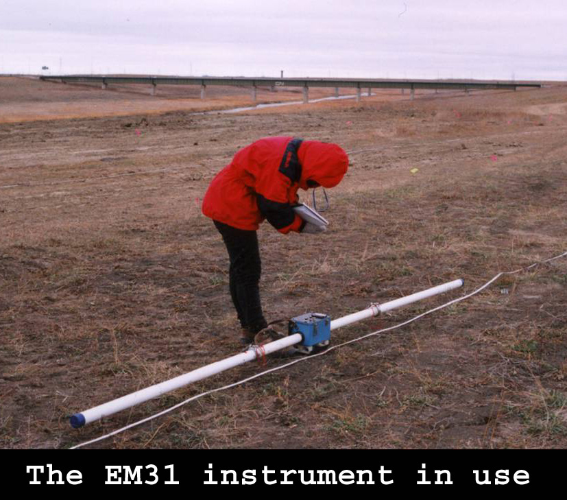 Surveys at the Red River floodway and Letellier sites. Geophysical
surveys at the Red River floodway site included electromagnetic/electrical
(EM31, EM38, DC-resistivity, PROTEM47) and seismic refraction methods.
The seismic refraction results resolved the thickness of the soil layer,
the combined thickness of the clay units, and the thickness of the till,
but not resolve the interface between Agassiz Unit 1&2 and Unit 3.
Small-scale EM measurements in the excavation pit revealed the conductivity
of the Agassiz Unit 1&2 to be 200 mS.m-1 and that of Agassiz Unit 3
to be 120-150 mS.m-1.
Surveys at the Red River floodway and Letellier sites. Geophysical
surveys at the Red River floodway site included electromagnetic/electrical
(EM31, EM38, DC-resistivity, PROTEM47) and seismic refraction methods.
The seismic refraction results resolved the thickness of the soil layer,
the combined thickness of the clay units, and the thickness of the till,
but not resolve the interface between Agassiz Unit 1&2 and Unit 3.
Small-scale EM measurements in the excavation pit revealed the conductivity
of the Agassiz Unit 1&2 to be 200 mS.m-1 and that of Agassiz Unit 3
to be 120-150 mS.m-1. 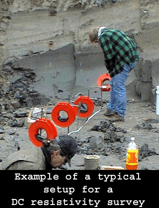 Surface
DC resistivity measurements identified three layers corresponding to more
resistive soil and Agassiz Unit 3, conductive Agassiz Unit 1&2, and
more resistive till/bedrock.
Surface
DC resistivity measurements identified three layers corresponding to more
resistive soil and Agassiz Unit 3, conductive Agassiz Unit 1&2, and
more resistive till/bedrock.
The most surprising results of the
geophysical surveys were the lateral variations in the electrical response.
Surveys using an EM31 in horizontal dipole mode (penetration 3 m) and vertical
dipole mode (5 m), DC resistivity profiling (5-10 m), and time-domain electromagnetics
(5-20 m) all revealed a broad resistive zone containing a more narrow conductive
zone coincident with the excavation pit (Fig. 3). These observations
suggest that the location of the deposit may be related to structures within
the overlying Agassiz Unit 3.
Initial geophysical surveys at the
Letellier site have revealed a conductive anomaly coincident with
the gypsum deposit. EM31 readings increase from 100 mS.m-1 in background
areas to 250 mS.m-1 in the anomaly. Conductivity readings correlate
inversely with, and may be partially controlled by, a corresponding 75
cm variation in surface topography. Readings in the dugout, where
gypsum rosettes were collected, are in the range of 190-220 mS.m-1, similar
to those from the excavation pit at the Red River floodway, but less conductive
than the overlying units. At both the floodway and Letellier sites,
there is an indication that the location of the gypsum deposits is related
to linear conductive features in the overlying units.
Interpretation and discussion

Full interpretation of the geophysical
results requires a detailed understanding of the electrical conductivity
of the Agassiz units. At the smallest-scale, factors controlling
conductivity include porosity, saturation, groundwater salinity, and clay
mineralogy. An initial sampling program at the Red River floodway
site has indicated grain-size and mineralogical variations across the anomaly.
Sampling studies are planned for the Letellier site.
One significant control on lateral
variations in the Agassiz clays is iceberg scouring of Agassiz Unit 1&2.
The scouring produced low-angle faults below the scour trough, which extended
at least 3 m below the scour, and high-angle normal faults outside the
scour (Woodworth-Lynas & Guigné, 1990). The scours can
be recognized on the present-day ground surface as linear features that
are on the order of 100 m wide and have topographic relief of several decimetres.
Shallow troughs at the margins of the scours have been deepened locally
by farmers to control surface runoff. The scours appear to influence
the near-surface hydrology, and the associated deeper structures, particularly
the normal faults, likely influence the deeper hydrological conditions.
In the absence of vertical structures, such as faults, the Agassiz clays
form an aquitard, with low hydraulic permeability across the laminae (Baracos
et al., 1980).
The geophysical results suggest a relationship
between gypsum rosette accumulations and linear anomalies in near-surface
units; iceberg scours can produce such linear anomalies. Hence, we
have started to investigate the geophysical response of iceberg scours
in the Agassiz clays. To date, geophysical surveys have been completed
over two scours in the Lorette area that were investigated by Woodworth-Lynas
& Guigné (1990). Electromagnetic survey results show conductivity
variations of a magnitude and form similar to those observed at the gypsum
sites.
| Home | Geology
| Geochemistry | Outreach
| Geological Sciences Homepage |